
Fire, flood, winds and earthquakes: satellite imagery reveals damage wrought by changing climate
Earth observation experts at the University of Leicester, Space Park Leicester and the National Centre for Earth Observation have released new satellite imagery demonstrating our world’s vulnerability to the effects of climate change.
The four examples, that represent the impacts of the changing climate through water, earth, wind and fire, are a small selection of the climate events that have caused devastation and upheaval around the world in the past few years.
They also demonstrate how the use of satellite imagery is providing valuable insight into these events, both during the disaster and in the aftermath. The University of Leicester employs around 300 academics and researchers working on space and earth observation, one of the largest groups in the UK. Space Park Leicester, the University’s £100M science and research hub, hosts the headquarters of the NERC-funded National Centre for Earth Observation.
Here, Earth observation experts explain what each series of images shows, and how they are proving useful in tackling climate change:
Flooding
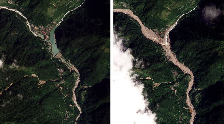
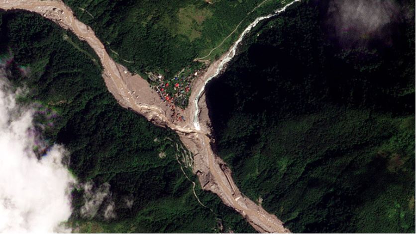
On 4th October 2023, during the Monsoon Season in the Indian State of Sikkim, a cloudburst saw Lhonak Lake receive five times the average rainfall. The lake’s banks were breached, unleashing a deluge through the mountain valleys, and affecting the lives of 22,000 individuals. Satellite imagery shows us that before the disaster the village of Chungthang was peaceful and the Teesta III Dam intact. Ten days later, the ‘after’ image reveals a scene of chaos: a collapsed dam, homes submerged, and a community in distress.
Dr Matthew Payne from the School of Geography, Geology and the Environment at the University of Leicester said: “This catastrophe is a stark reminder of the escalating challenges faced by the verdant Himalayan regions, and the increasing magnitude of flooding events necessitates resilient infrastructure capable of tolerating climate-induced excessive rainfall. With satellite imagery, we can track the onset, duration and retreat of floodwaters, providing crucial insights for relief and recovery efforts.”
Wildfires
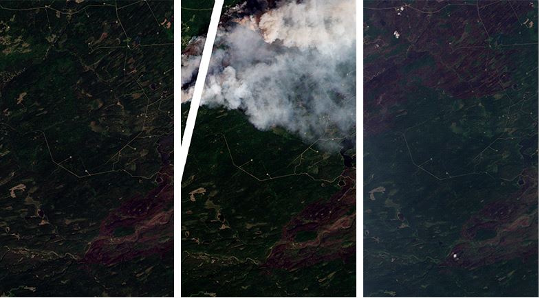
In this trio of images, we see the vast Canadian wilderness of the Bearhole Lake Protected Area under siege from wildfire in June 2023. In the ‘before’ shot, we see a burn scar in the South-East, hinting at fires come before. The ‘during’ shot shows the frontier of the wildfire and the resulting smoke trail as it carves through the forest, whilst the ‘after’ shot shows the scale and aftermath of the devastating fire.
Professor Kevin Tansey from the School of Geography, Geology and the Environment added: “These images are a glimpse of the most intense wildfire season Canada has seen in recorded history (1983) and are a snapshot of the 185,000 km2 of land burned this year, a staggering 6 times the average annual burned area. The value of satellite imagery has never been more evident, here the potential direction of the wildfire can be discerned, assisting emergency services with evacuation and fire control efforts, whilst enabling the quantification of the scale of these wildfires.”
Hurricanes
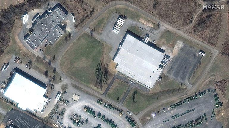
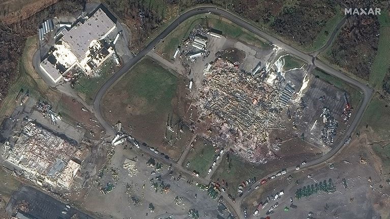
In these images we see the Mayfield Consumer Products Factory in Kentucky, USA, known for producing scented candles. The ‘before’ image shows us the candle factory in 2017, while the ‘after’ image from December 2021 shows the factory’s ruins following its decimation by a tornado. This tornado resulted in 9 fatalities and over 100 injuries.
Professor Kevin Tansey said: “These images highlight that even in the aftermath of Hurricane Ida in late August of that year, the second-most destructive hurricane in US history, severe wind damage is still a threat outside of the hurricane season. They provide a detailed view of the extent of climate-related devastation, offering further evidence of the increasing frequency of climate disasters.”
Earthquakes
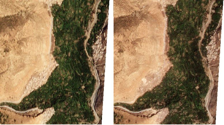
The once bustling streets of Imi N’Tala and Ineghede in the Marrakesh-Safi region of Morocco are captured in these satellite images. A devastating magnitude 6.7 earthquake struck the region, killing 70 people as buildings collapsed in both towns. In the ‘after’ image, we see the scale of the destruction.
Dr Matthew Payne said: “These images show us how vulnerable remote communities are from natural hazards, highlighting the precarious relationship we have with the Earth. Such images demonstrate that satellites are invaluable for understanding the impacts of earthquakes on remote communities, ensuring that remoteness does not mean being overlooked.”
Images provided by MAXAR are through the University of Leicester’s Manufacturing, Engineering, Technology and Earth Observation Research Centre (METEOR) collaboration. The centre co-locates over 100 researchers and industrial R&D personnel, bringing together industry and academics to drive forward the evolution of the UK space sector. METEOR received funding of £13.75M for a 5,000 m2 research and innovation facility from Research England, through its capital infrastructure mechanism, UK Research Partnership Investment Fund (UKRPIF) provided.
Dr David Moore from the National Centre for Earth Observation said: “Satellite imagery from Planet and MAXAR provides an extremely detailed view of the Earth’s surface, allowing scientists to study the impacts of extreme events which have a profound effect on communities around the world. The imagery offers invaluable support for the conversations of policy-makers at COP28, particularly in aiding vulnerable communities affected by climate change, by enabling the quantification of loss and damage sustained by these communities due to climate-related disasters.”
- Find out more about the University of Leicester’s involvement at COP28: https://le.ac.uk/research/sustaining-world
- Find out more about the University of Leicester