Protecting Kenya’s forests with deforestation alerts from space
Between 1990 and 2016, the world lost 1.3 million square kilometres of forest. As estimated by the World Wide Fund for Nature (WWF), that is a loss of 27 football fields of forest every minute due to deforestation.
The Paris climate agreement aims to reduce deforestation to protect the climate and as part of its implementation, satellite monitoring is needed to oversee progress and warn of unlicensed logging.
Since 2014, the University of Leicester has been working in partnership with the Kenya Forest Service (KFS) to co-develop Forest Alert, a rapid deforestation monitoring system based on Copernicus sentinel-2 images.
Forest Alert allows the KFS to accurately monitor their tree cover and react quickly to any changes. It has been developed in partnership with a range of stakeholders in Kenya, including Community Forest Associations, formed by communities that live adjacent to forests and who are a key element in forest conservation and management.
The Government of Kenya has pledged to increase its forest cover from 6% to 10% of its land area by 2030. However, land taken for agriculture, logging and fuelwood collection still lead to some destruction of precious forest land. Climate change impacts and extreme droughts exacerbate the problem.
A challenge of managing Kenya’s forest resources lies in its vast land area. Rangers from the Kenya Forest Service do not have capacity to patrol all forest lands on a regular basis making it difficult to halt the destruction of forest areas at an early stage.
Forest maps from satellite images provide important information on the state and health of Kenya’s forests. However, producing a national forest map is a time-consuming task and by the time the new map is finished, some of the mapped forest areas may already have been destroyed. Rapid deforestation alerts are needed to provide timely information on new logging activity to forest managers.
The Copernicus Sentinel-2 satellite mission provides new images of the world’s entire land area every 5 days at a detailed 10 metre spatial resolution – fine enough to see even single tropical trees being cut down or blown over by a storm. However, as the satellite images are so frequent sifting through a vast amount of big data every week is a huge challenge – rather like looking for a needle in a haystack.
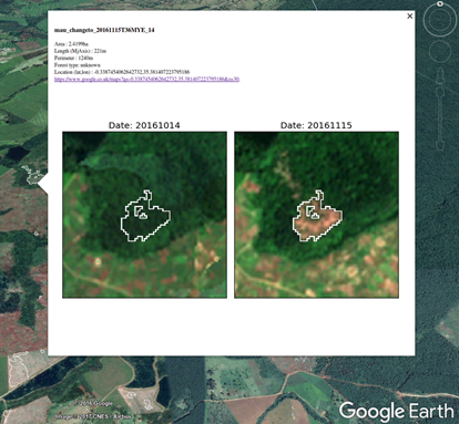
The solution to the big data problem is to automate the whole process from searching the European Space Agency’s data server for a new image to download and correct the images from any atmospheric parameter. When the images reach the server, they are compared with the previous image using a machine learning algorithm called a ‘random forest’ that automatically looks for areas where forest cover loss is likely to have occurred, based on training data of past deforestation events. Each alert shows the image before and after the detected event, its location and the area affected. If there are any differences in the images, an alert is sent to the KFS and registered users. Even small scale logging can be detected through the accuracy of the algorithm.
The change in the image is checked for false alarms and forest rangers are then alerted; they will visit the location and report back using an app. All of this process can happen within 24 hours of the satellite taking the image from space, greatly cutting down the response time for investigating forest areas of concern. Crucially, the information is available before the entire forest area has been lost.
Why is this important?
The deforestation alert system has the best spatial detail and speed of detection of new deforestation events. It is now being used routinely by the Kenya Forest Service to keep an eye on some of Kenya’s protected forest areas. With the help of the satellite alerts and a mobile app the forest rangers in the field and local people living in the area can report what they see to the Kenya Forest Service. The information received is subsequently collated in the head office in Nairobi. An evaluation of the new system has shown that the satellite alerts are creating awareness of new areas of deforestation that the rangers did not know about. Rapid information means that forest governance has become more effective, and Kenya can protect its precious forest resources much better than before.
Forest alert is an excellent collaboration in education and research between Kenya and the UK.
Forest Alert has been funded by a variety of sources including NERC, QR GCRF and the UKSA Forest 2020 project led by Ecometrica and won the 2017 Copernicus Masters award for Sustainable Living Challenge. The UK Government presented the Forest Alert system to President Uhuru Kenyatta when he met with COP26 President-Designate Alok Sharma at a special event at Kew Gardens on Tuesday, 27 July 2021.